Masnaghetti maps Bordeaux

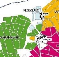
Alessandro Masnaghetti, Italy's undisputed expert on terroir, has literally put Italy's vineyards on the map, whether on paper or in iPad form as can be read here. But now he has ventured with camera and pencil outside the peninsula and straight into the lion's den of the Médoc to meticulously record every inch of the vineyards including altitude, exposition, soil type and grape varieties planted.
Although this is Masnaghetti's first cartographical assault on Bordeaux, it is certainly not his first encounter as he has been tasting and evaluating every Bordeaux vintage for the last 20 years, something he once explained to me as 'a little private passion on the side'. [I can confirm sighting Alessandro over many a primeurs tasting table over the years – JR.]
The World Atlas of Wine does a pretty good job of showing which vineyard is where [thanks, Walter – JR], but Masnaghetti's map goes into much more detail, recording the exact ownership of each parcel in St-Estèphe, Pauillac and St-Julien, and that's for starters.
Apparently, it took a huge effort to explain why he wanted quite so much information as the Bordelais are normally quite tight lipped, but most complied and gave Masnaghetti access to the material needed. The exceptions were Châteaux Ducru-Beaucaillou, Lynch Moussas, Batailley and Pontet-Canet, giving rise to delicious speculation as to the reasons for their refusal.
As always, Masnaghetti's goal is to spread the gospel, and hence this map, available from 10 April, can be purchased for the modest sum of €7 (all enquiries: masna@enogea.it), while the iPad and iPhone versions will be available in May 2012.
See some extracts below.


Become a member to view this article and thousands more!
- 15,426 featured articles
- 274,442 wine reviews
- Maps from The World Atlas of Wine, 8th edition (RRP £50)
- The Oxford Companion to Wine, 5th edition (RRP £50)
- Members’ forum
- 15,426 featured articles
- 274,442 wine reviews
- Maps from The World Atlas of Wine, 8th edition (RRP £50)
- The Oxford Companion to Wine, 5th edition (RRP £50)
- Members’ forum
- Commercial use of our Tasting Notes
